
Mapped by Their Own Hands
Mapped by Their Own Hands
Around 1728, a Cree guide named Ochagach drew a map on birch bark showing the water route from Lake Superior to the far interior — lakes, rivers, portages, and the nations that lived along them. The French officer who received it sent it to Paris. Twenty-five years later, a Parisian geographer engraved it onto copper and published it for the world. The original knowledge was Anishinaabe. So was Marie Josephte Abitakijikokwe's world.
Most genealogists who trace French-Canadian ancestry into the fur trade era encounter, eventually, the word Saulteaux. It appears in baptism records, marriage registers, census entries — a colonial label that erases the specificity of entire nations and territories. What it cannot erase is the geography behind it. The Saulteaux, the People of the Rapids, lived in a world their ancestors had mapped with extraordinary precision, long before any European cartographer arrived.
Those maps survive. Not in the form the original makers intended — birch bark does not last centuries — but filtered through colonial hands that nonetheless preserved the essential knowledge. Looking at these maps today, a genealogist researching Marie Josephte Abitakijikokwe can see, with reasonable clarity, the landscape she came from. The lakes she may have crossed as a child. The portage routes that connected her world to the one where she would eventually raise her children.
This is her world, as her people mapped it.
The Birch Bark Map
The Cartographer
When La Vérendrye arrived at Fort Kaministiquia in the mid-1720s to take command of the fur trading post at what is now Thunder Bay, Lake Superior, he was not the first European to dream of finding a water route to the Pacific. He was simply the one who thought to ask the right person.
That person was Ochagach. A guide, a navigator, a man whose knowledge of the western waterways had been accumulated over a lifetime — and who, in the winter of 1728, agreed to commit some of that knowledge to a medium La Vérendrye could read: a map, drawn on birch bark, showing the canoe route from Lake Superior westward to Lake Winnipeg and beyond.

Carte tracée par le Sauvage Ochagach et autres — "Map drawn by the Savage Ochagach and others." This reproduction, made from the copy held at the Dépôt de la Marine in Paris, shows the water route from Fort Kaministigoïa (Thunder Bay, Lake Superior) westward through the lake-and-portage chain to Lake Winnipeg. At the far left, the notation reads Montagnes de pierres brillantes — "Mountains of Bright Stones." One of the earliest recorded references to the Rocky Mountains.
What Ochagach produced was not a map in the European sense — it made no attempt to render distances to scale or to represent geographic features in anything like their true proportions. Instead, it was a route map: a precise record of connections. Lakes were nodes. Portages were the intervals between them. The chain of small ovals across the upper portion of the map represents each portage and each body of water, strung together like beads — a cartographic language designed to answer the traveler's most practical question: How do I get from here to there?
Modern scholars have compared Ochagach's map to a subway diagram — not a faithful geographic rendering, but an accurate network map. The distances between portages are compressed or expanded to make the connections legible. What matters is the sequence, the relationship between nodes, the knowledge of where you must carry your canoe and where you can paddle freely. This was the intelligence that La Vérendrye needed, and that Ochagach provided with precision.
It also reflects a distinctly Indigenous spatial logic: the land understood in terms of how you move through it, not how it appears from above. The map encodes practical knowledge accumulated over generations of travel, trade, and seasonal movement.
La Vérendrye transmitted the map, along with his report, to the Governor of New France in 1730. It then made its way to the Dépôt de la Marine in Paris, where the French hydrographer Nicolas Bellin later noted that it was the earliest drawing of the region west of Lake Superior in the entire collection. The original birch bark has not survived. What we have is a series of copies — each one a generation removed from Ochagach's own hand, but preserving the essential geography.
From Birch Bark to Paris
Ochagach's map did not stay in the pays d'en haut. It traveled east and then across an ocean, passing through hands that increasingly misunderstood what it represented while nonetheless recognizing its value. Tracing that journey helps us understand both how much was preserved and how much was reinterpreted along the way.
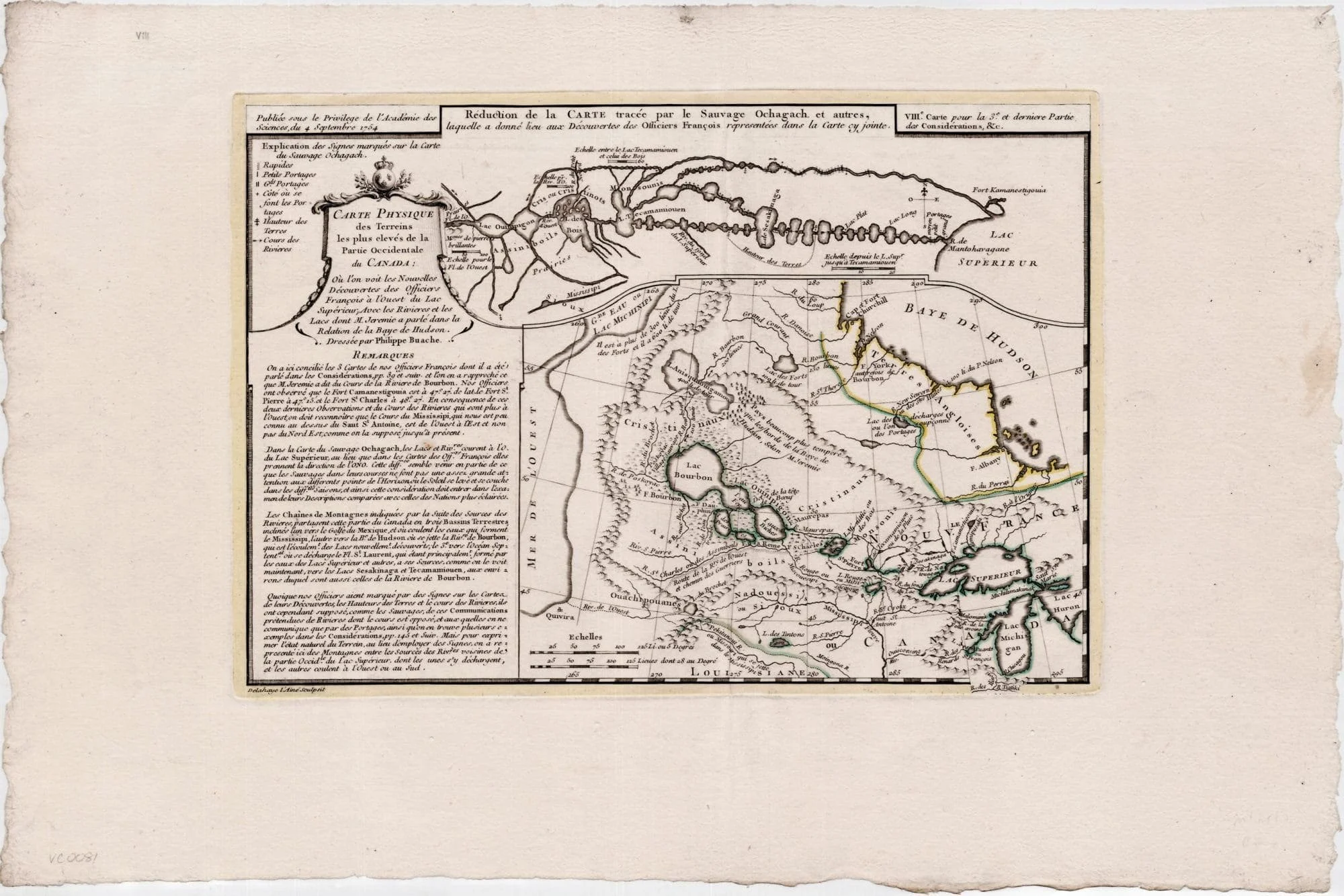
Two maps on one sheet. The small map at the top is Buache's reduction of the Ochagach map — the birch-bark original filtered through La Vérendrye's composite, now engraved in copper. The large map below synthesizes the French expedition reports of the 1730s, showing Fort St. Pierre (Rainy Lake), Fort St. Charles (Lake of the Woods), and Fort Bourbon (Lake Winnipeg), linked by the waterways Ochagach had described a quarter century earlier. At the far left, the conjectured Mer de l'Ouest — the Sea of the West — represents the European fantasy Ochagach's practical geography was made to serve.
Buache was not primarily a man of the field. He was a cabinet geographer, a theorist, a man who worked from manuscript reports and created printed syntheses for European audiences. He used Ochagach's map to support his theory of a continuous water route from Lake Superior to the Pacific — a theory that was wrong. But in pursuing that wrong theory, he preserved and published one of the earliest surviving examples of Indigenous cartography in the Western Hemisphere.
"Nicholas Bellin wrote in 1755 that this was the earliest drawing of the region west of Lake Superior held by the Dépôt de la Marine."
The Portage Chain: Reading the Map
The most visually distinctive feature of the Ochagach map — and of every map that copied it — is the chain of ovals across its upper portion. These represent the portage route: the sequence of small lakes, rivers, and carrying-places that connected Lake Superior to the interior. Generations of travelers, both Indigenous and European, knew this route by the same series of landmarks.
The Route West, as Ochagach Mapped It
Reading the portage chain from east to west — the same direction Gabriel Guilbault would have traveled as a voyageur, and the same direction Marie Josephte's ancestors moved through the boundary waters:
The chain of ovals visible in the upper section of both the Ochagach map and the Carver manuscript is a direct visual representation of this knowledge. Each oval is a lake or expanded river section; the narrow connections between them are the portages. Ochagach drew what every experienced traveler in this region already knew: that the boundary waters were not a barrier but a highway, navigable by canoe through a precise sequence of water bodies and short overland carries.
The Same Knowledge, Half a Century Later
In 1766, a colonial American officer named Jonathan Carver set out from Fort Michilimackinac to explore the interior waterways of the Great Lakes region — traveling routes that French voyageurs and their Indigenous partners had used for generations. His map, produced around 1766–67 and published in 1778, shows the same geography Ochagach had described, filtered now through English rather than French colonial eyes.
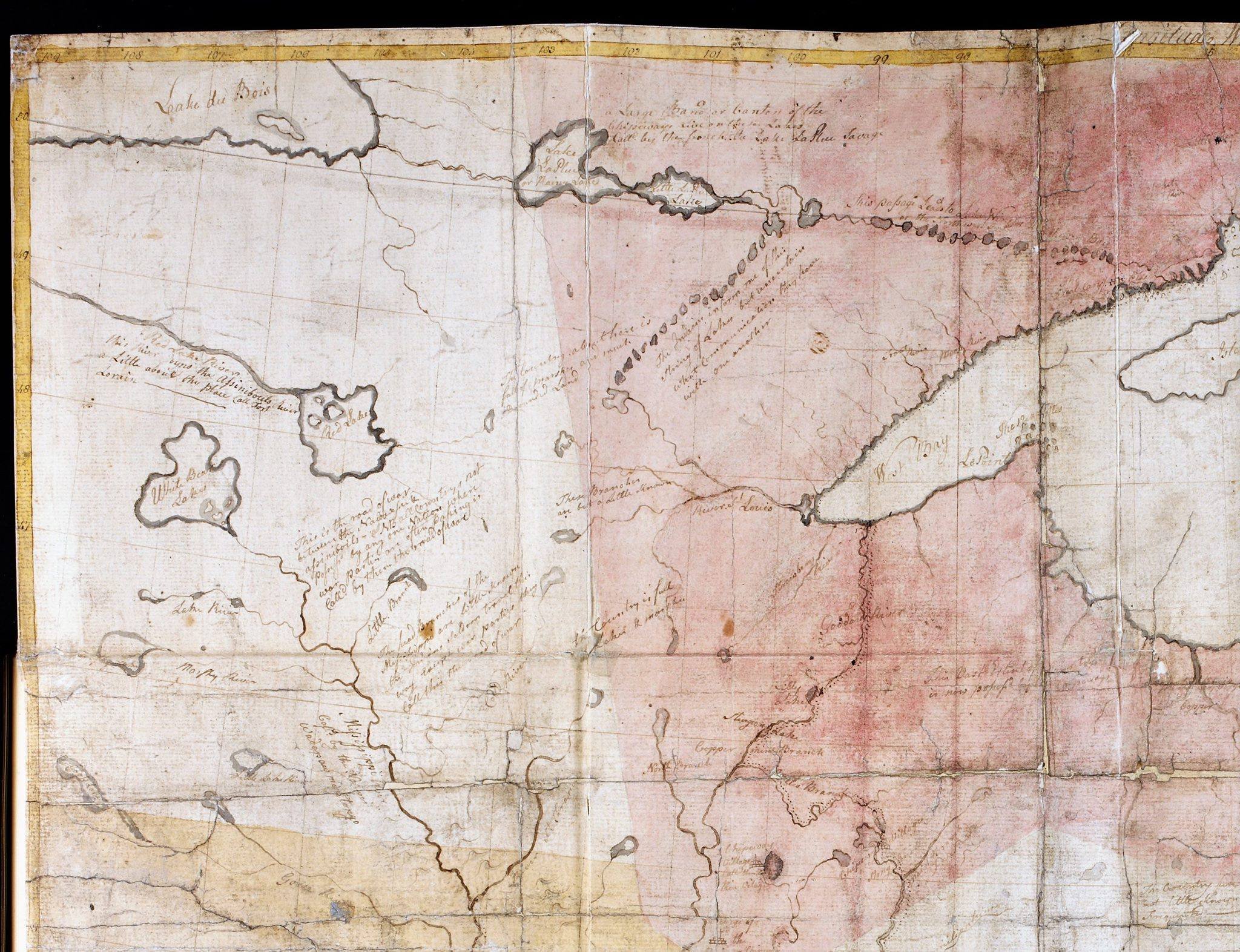
The portage chain is immediately recognizable in the upper right — the same chain of ovals that Ochagach drew nearly forty years earlier. "Lake du Bois" (Lake of the Woods) appears upper left. The pink wash marks territorial boundaries in the British colonial understanding. The handwritten annotations, still legible on the original, document Indigenous place names, trade routes, and the territories of specific nations. The Chipeways — the Ojibwe — are identified across the vast territory north and west of Lake Superior that was Marie Josephte's homeland.
Carver labeled the nation whose territory he was moving through: The Chipeways. This was the Ojibwe people — the same nation Father Leclerc would identify as Marie Josephte's own when he recorded her baptism at Oka in January 1801. The Carver map predates that record by thirty-five years. It shows her people's territory as Carver understood it, in the decades when she would have been a child and young woman.
Forty Years of the Same Knowledge


The persistence of the portage chain across these maps — Ochagach's original, Buache's engraving, the Carver manuscript, the Carver printed map — is not coincidence. It is evidence. These European and colonial cartographers were not independently discovering the same route; they were recording knowledge that Indigenous travelers had codified over generations. The chain of ovals was Anishinaabe knowledge in European ink.
Marie Josephte's World
When Father Leclerc dipped his quill in January 1801 and wrote that Marie Josephte was "de la Nation Sauteuse sur le Lac Supérieur," he placed her in the center of the world these maps describe. The Saulteaux — the Baawitigowininiwag, the People of the Rapids — lived at and around Sault Ste. Marie, but their canoe routes extended throughout the boundary waters, along the portage chain that runs across every version of these maps.
Marie Josephte was born around 1760 — roughly thirty years after Ochagach drew his map. She would have grown up navigating the same waterways. The lake-and-portage logic that Ochagach committed to birch bark was not abstract geography to her; it was the shape of daily life.
What the Maps Tell Us
Father Leclerc's brief notation in 1801 — "de la Nation Sauteuse sur le lac Supérieur" — names a nation and a lake. These maps fill in what that meant: a world of interconnected waterways stretching from Lake Superior westward through the boundary waters to Lake Winnipeg and beyond, governed by Indigenous knowledge of every portage, every current, every seasonal campsite along the route. Marie Josephte came from a people who had mapped this world before Europeans arrived, and whose cartographic knowledge shaped every French, British, and American map that followed.
By the time she traveled east with Gabriel to Oka in January 1801, Marie Josephte had likely crossed sections of this route in reverse — moving from the Lake Superior world toward the Ottawa River watershed, following the trade routes that connected the pays d'en haut to the St. Lawrence settlements. The voyageurs' highway was the Anishinaabe highway. Gabriel knew the route as a voyageur. Marie Josephte may have known it as home.
Colonial records identify Ochagach as Cree, and La Vérendrye's journals use that label. But historians have noted the ambiguity. He operated in territory where Cree, Ojibwe, and Assiniboine peoples overlapped significantly, in a region whose distinct cultural blend gave rise to the Oji-Cree (Anishininew) people. Some scholars suggest he may have been associated with the Monsoni, a group from the Rainy Lake district who allied closely with both Cree and Ojibwe and were eventually assimilated into the Ojibwe nation.
La Vérendrye described Ochagach as "the man most capable of guiding a party" — a practical assessment that valued his knowledge over his ethnic categorization. Ochagach identified the Grand Portage–Pigeon River route as superior to the Kaministiquia River route that earlier French travelers had used; La Vérendrye adopted this path in 1732, and it became the primary trade artery of the North West Company for decades, eventually helping define the modern Canada–U.S. border.
Whatever his specific affiliation, Ochagach was part of the same Anishinaabe world that Marie Josephte inhabited. His map is a window into her world.
The Guilbault Line Series
The Guilbault Line: A Documentary Biography Series →
The complete series tracing seven generations from the pays d'en haut to the present.
Baawitigong: The Place of the Rapids →
The world where Marie Josephte and Gabriel's lives first intersected — Sault Ste. Marie and the St. Mary's River.
Dans le Bois: Death in the Hunting Grounds →
Three Oka Mission burial records document what happened when families died far from the mission cemetery.
Want to Know When New Stories Are Published?
Subscribe to receive updates on new family history research—no spam, just meaningful stories when there's something worth sharing.
SUBSCRIBE TO OUR NEWSLETTEREvery Family Has a Story Worth Telling
Whether you're just beginning your research or ready to transform years of work into a narrative your family will treasure, I'd love to hear your story.
BEGIN YOUR RESEARCH INQUIRY